An Official Vermont Government Website

Vermont Protected Lands Data Standard

Version 2025 | October 8, 2025

Purpose

The Vermont Protected Lands Database (VPLD) is a general reference of which lands are conserved where, by whom, and by which means throughout the state, based on ownership and/or legal restrictions. It is designed to help clarify the amount, type, and extent of protected lands statewide.

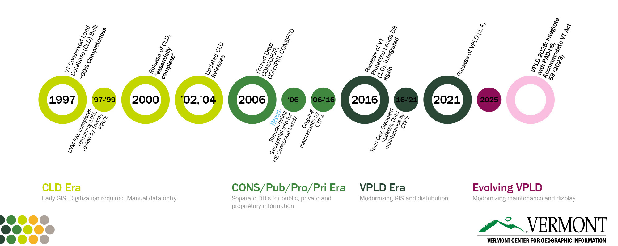
The VPLD displays best-available information from conservation institutions and is aggregated by the Vermont Center for Geographic Information (VCGI). As of 2025, the VPLD also provides USGS’s Protected Areas Database of the United States (PAD-US) with consistent updates of these lands in Vermont, while also depicting protected areas’ status relative to Vermont Act 59 of 2023.

Although it contains best-available map information, the VPLD is not a legal survey, conveyance or description of property and is intended for planning purposes only. Questions about specific protected areas should be directed to the protecting entities themselves, which typically is the organization listed in PAGENCY1.

Scope

Standard computer field names, codes, categories, and formats for spatial records of protected land areas in Vermont, whether they are public or private lands. Included lands are protected by ownership and/or legal restrictions.

Contents

The VPLD includes land parcels that are expected to remain protected from land conversion or development. Protection instruments include fee ownership, easements, deed restrictions, and more. Example protected areas are:

  • Public lands held by organizations with conservation or natural resource-oriented missions
  • Municipal holdings (e.g., town forests, fire district lands, watershed areas, school wood lots)
  • Public boating and fishing access areas
  • Public and private educational institution holdings with natural resource uses and/or protections
  • Publicly-owned rights on private lands
  • Parcels owned in fee by non-governmental organizations dedicated to conserving land or resources, in which if not legally protected, conversion would breach mission statements and/or nonprofit tax status
  • Private parcels with conservation easements held by non-governmental organizations

Applicability

Compliance with this standard is recommended for any municipal, regional, state, federal, or nongovernmental data manager who creates or updates geospatial data describing protected land in Vermont.

Any state agency that supplies funds to organizations or regional planning agencies to develop or update geospatial data regarding protected lands in Vermont should require that this standard be used.

There is no intent to provide a standard for developing the authoritative definition of property boundaries or to specify limits for legal boundary determination or property conveyance purposes. Those definitive interests remain the purview of the professional title attorney and/or licensed land surveyor.

Data Contributors

The following institutions contribute data to the VPLD. Their contributions may also reflect conserved lands held by other institutions operating in Vermont.

Indirect data contributions reflecting Federally-controlled protected lands are sourced from the PAD-US database. These include lands protected in Vermont by the United States Forest Service (USFS), etc.

The VPLD contains data aggregated in years past and has records that may not have a current data steward. Accuracy and currentness of these records without a data steward should be carefully considered.

Future contributions may be accepted by organizations whose holdings are not represented by the above contributors.

Specifications

Requirements

Data contributors are expected to periodically update and/or submit to VCGI their conserved lands data adherent to this data standard if they wish for their holdings to be included in the Vermont Protected Lands Database. See the other parts of the specifications section for compliance, and the submittals section for more information on update formats, timing, and details.

Schema

The full schema of the current VPLD data standard is available below, with additional descriptive fields to provide context. The table is searchable via the search bar at top left. See the descriptive field STATUS to see if a field is new, changed, or existing relative to the most recent VPLD data standard v.1.4. Fields with coded values are marked with Yes in the Coded field, and may have full tables of valid domains in the Domains section of this document.

Importantly, PTYPE1, PTYPE2, PTYPE3, PTYPE4, and PTYPE5 values are to correspond exactly with the respective PAGENCY1, PAGENCY2, PAGENCY3, PAGENCY4, and PAGENCY5 values for each record.

In other words, PTYPE1 ≘ PAGENCY1, PTYPE2 ≘ PAGENCY2, and so on.

Data contributors should not enter data in fields marked By VCGI in the Entry column of the table below, including INT_ORGTYP, SOURCE_LAYER, SOURCE_ACR, GISACRES, AGGDATE, and OWNERKIND. These fields will be populated by VCGI at each aggregate update and are based on other fields populated by data contributors for each of their records.

Templates

View Best Available Data Download File Geodatabase Template

A web service is also available for streaming the composite standardized data.

Standardized Composite Data Service

A crosswalk table is available that reflects how data adherent to the VPLD data standard v.1.4 can be converted to this version. This crosswalk pertains to converting values for:

  • the PAGENCY1, PAGENCY2, PAGENCY3, PAGENCY4, and PAGENCY5 fields (all use the same list of PAGENCY values)
  • the PTYPE1, PTYPE2, PTYPE3, PTYPE4, and PTYPE5 fields (all use the same list of PTYPE values)
  • the SOURCE field

Download Crosswalk Table (.xlsx)

Domains

Protection Types (PTYPE 1 - 5)

These coded values apply to the Protection Type 1 through Protection Type 5 fields: PTYPE1, PTYPE2, PTYPE3, PTYPE4, and PTYPE5.

Protection Agency (PAGENCY 1 - 5)

These coded values apply to the following fields: PAGENCY1, PAGENCY2, PAGENCY3, PAGENCY4, PAGENCY5, and GISSTEWARD.

Designation (DESIGNAT)

These coded values apply to the DESIGNAT field.

Source Types (SOURCE)

These coded values apply to the SOURCE field.

Public Access (PUBACCESS)

These coded values apply to the PUBACCESS field.

GAP Status (GAPSTATUS)

These coded values apply to the GAPSTATUS field. They mirror those of the USGS PAD-US Gap Analysis Project. USGS provides a GAP Status Assignment Tool to help record classification.

Primary Interest Organization Type (INT_ORGTYP)

These coded values apply to the INT_ORGTYP field. They reflect the monitor of property organization type, auto-populated by the value of PAGENCY1.

Source Acronym (SOURCE_ACR)

These coded values apply to the SOURCE_ACR field. They reflect the acronyms of data contributors, auto-populated by the value of SOURCE_LAYER.

VT ACT 59 Category (ACT59CAT)

These coded values apply to the ACT59CAT field. See the Act 59 section below for more detail.

Vermont Act 59 of 2023 (Community Resilience and Biodiversity Protection Act)

Vermont Act 59 of 2023, also known as the Community Resilience and Biodiversity Protection Act (CRBPA) or the "30 by 30, 50 by 50" bill:

establishes State goals of conserving 30 percent of the land of the State by 2030 and 50 percent by 2050. It requires the Vermont Housing and Conservation Board in consultation with the Secretary of Natural Resources to develop an inventory of the existing conserved lands in the State and a plan on how to reach the goals.

While the VPLD is not the same as Act 59 and its specifications, the VPLD data standard now permits protected lands within it to also be classified according to their Act 59 status.

The Vermont Agency of Natural Resources has developed a guide for VPLD data contributors to classify their VPLD records according to a respective Act 59 category. This is to be completed in the ACT59CAT field for each record, using the Act 59 categories specified in the Act 59 domains table and described in the guidance document. Additional guidance on how to class VPLD records to their Act 59 category may be a component of ongoing VPLD data review as described in the Review section of this document.

Download Act 59 (CRBPA) Categorization Guidance (.pdf)

Mapping

Coordinate System

Data contributors should submit data in the most recent edition of the Vermont State Plane Coordinate system as specified by 1 V.S.A. §§ 671 - 679.

VCGI will coordinate with data contributors and update geodatabase templates when the current NAD83 / EPSG:32145 coordinate system is replaced by the forthcoming, finalized VT State Plane Coordinate System of 2022 (VTSPCS 2022).

Attribution

At a minimum, fields marked Yes in the Required column of the schema table above are expected to be completed for all records. Data contributors should also review and continuously improve their attribution with respect to adjacent or duplicate holdings. Duplicate areas represented by another protecting entity should be reviewed by all parties with overlapping interest to establish whether the same area should solely be included in a higher-order PAGENCY's holdings. In this case, the higher-order PAGENCY should also confirm how to attribute the record to properly reflect the interests of the lower-order PAGENCY in one polygon.

Geometry

As protected lands geometry is maintained by multiple contributors and based on multiple sources, there may be persistent gaps and overlaps among adjacent polygons. Data contributors should review and continuously improve their geometry with respect to adjacent or duplicate holdings, and particularly those reflecting interests of another protecting entity. Duplicate areas represented by another protecting entity should be reviewed by all parties with overlapping interest to establish whether the same area should solely be included in a higher-order PAGENCY's holdings. In this case, the higher-order PAGENCY should also confirm how to attribute the record to properly reflect the interests of the lower-order PAGENCY in one polygon.

Recurring reviews of VPLD data by contributors should focus on geometry and attribution issues within and across holdings of protecting entities. VCGI will publish and maintain data quality review tools and products to help facilitate ongoing geometry and attribute improvements. Together, these reviews and resources would ideally lead to a reduction in duplicate records and egregious gaps or overlaps.

Example of overlapping records 
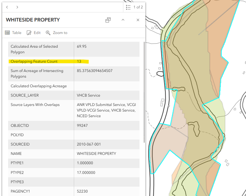
An example of overlapping records in review tools that likely would benefit from coordination and modifications from respective data contributors, as seen in the Source Layers With Overlaps field in the popup. Note: this field is only found in data quality review products intended for use by data contributors. It is not part of the VPLD data standard itself.

Federal Data Handling

The most recent edition of the Protected Areas Database of the United States (PAD-US) is used in the VPLD to represent lands with Federal interests. To reduce instances of overlapping protected areas in the VPLD, PAD-US records go through an automated review to determine whether they are already represented by another source. PAD-US records attributed with National-level DESIGNAT values are kept in the VPLD, even in instances where they overlap other VPLD records.

Metadata

VCGI will publish the aggregate VPLD dataset sourced from data contributors adherent to the Vermont Metadata Standard. VCGI may contact data contributors to complete any missing information for their respective holdings.

Submittals

Data contributors should produce updated data to be read or sent to VCGI at quarterly intervals. In order of preference, data should be provided as one of the following:

  1. Standard-compliant service URL accessible by VCGI. Schema matches VPLD exactly. VCGI will automatically read the service URL during quarterly updates.
  2. Standard-compliant geodatabase or shapefile. Schema matches VPLD exactly. Contributors should send updated data to VCGI via email by the dates listed below. If a shapefile is used, coded values that match the domains in this standard should be used.
  3. Non-standard-compliant service URL accessible by VCGI. VCGI will attempt to match the provided schema as best as possible to the VPLD. VCGI will automatically read and re-match the schema of the service URL during quarterly updates.
Data contributors who supply VCGI with a stable service URL should notify VCGI of a change to those services with at least 30 days notice to ensure ongoing, standard-compliant data updates.

Contributors submitting data via method 2 above should send updated files to VCGI by these dates each year:

  • February 1
  • May 1
  • August 1
  • November 1
The VPLD will be updated with data from all contributors within a week of these dates.

Contact VCGI About VPLD Updates

Submittal Status

The following table lists data updates by contributors and their status of being sent to VCGI for compilation and publishing. It will be updated for each publishing cycle.

Review

ANR should assemble an workgroup of contributors to promote ongoing improvements to the VPLD that meets at least annually. This workgroup should use tools provided by VCGI to analyze and resolve areas of overlap, duplicate records, and other discrepancies that may appear in the dataset. VCGI will provide and maintain map applications and layers to assist with this review.

Suggested Changes

The following table lists suggested changes to the VPLD data standard after May 15, 2025 and their status relative to the final VPLD data standard release.

Accepted changes will be made all at once pending final review by data contributors, VCGI, and the Enterprise GIS Consortium. Edits will be included within the final data standard and resulting templates, and any significant impacts to data contributor submissions will be crosswalked by VCGI.

Updates and History

Date Version Notes
October 8, 2025 Version 2025 approved by VT Enterprise GIS Consortium
August 13, 2025 2025 Review of 2025 VPLD Data Standard by VT Enterprise GIS Consortium, Begin Public Comment Period
May 15, 2025 2025 Updated VPLD Data Standard for Data Contributor Review
November 30, 2020 1.4 Removed leading 0’s in PAGENCY field for Municipal Codes 0-29,999;
November 9, 2016 1.3 Posted version approved by EGC
March 2015 1.2 Changes based on input from contributing partners
September 2014 1.1 Changes based on input from contributing partners

2025 VPLD History Timelinev2

Statutory Authority

The Vermont Center for Geographic Information (VCGI) has the statutory authority to craft and adopt VT GIS standards and guidelines. VCGI works with the VT GIS community to carefully craft these standards and guidelines, helping to ensure that Vermont GIS (VGIS) data “is compatible with, useful to” others in the VT GIS community.

The State’s Enterprise GIS Consortium (EGC) is established as the organization responsible for reviewing and approving Vermont GIS standards crafted by VCGI (in collaboration with the Vermont GIS Community).

Acknowledgements

The 2025 VPLD data standard and resulting statewide data update is a product of many contributors, including the following individuals who have donated substantial time to the cause: